Blue Ridge Trail
|
The 4 mile Blue Ridge Tail loop at Natural Bridge State Park hike can be divided into five sections.
The park asks that you leave no trace; pack out everything you carry with you, collect your pet's waste, keep pets on a lease, be aware of bears and leave only footprints. |
Description
From the parking area, bear right following the trail signs to begin a short climb to the top of an earthen dam. This is the beginning of the loop.
– This description is in a clockwise direction.
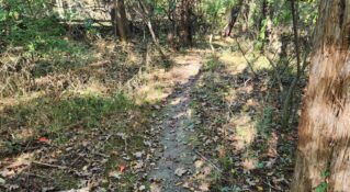
There is a sign for the Blue Ridge Trail, and it is marked with blue blazes. The trail begins as a mowed path through a large meadow. This region was at one time going to be a golf course for the hotel. This section also parallels the Thistle Ridge Disk Golf Trail.

The Blue Ridge Trail begins several easy descents and climbs through the meadow. The meadow is to the left. Several species of wildflowers flourish in the tall grasses of the meadow including milkweed. It is a favorite of the Monarch butterfly, In the fall, they can sometimes be seen flitting from one plant to plant to another. A thicket of Virgina pine and Eastern red cedar line the right side of the trail.

At 0.65 miles there is a signpost for a trail junction. Turn right and continue to follow the trail. The Blue Ridge Trail comes to another junction at 0.7 miles. Continuing straight leads to the Natural Bridge Hotel. The distance to the hotel is 0.4 miles.

To continue on the Blue Ridge Trail, take the right fork. This begins the second section of the trail. It continues to follow an old logging road with an easy climb and bending to the right as it enters the Cedar Creek watershed. The distance is 1.0 mile. Cedar Creek can be heard downhill on the left. The forest is composed of early successional hardwoods after having been logged around the turn of the century. The trail makes a long bend to the right and begins a long descent as it leaves Cedar Creek behind and enters a smaller unnamed creek drainage. At 1.5 miles There is a bench overlooking this small creek. There is a hard right bend at 1.6 miles as the trail begins to climb toward Red Knob.

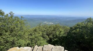
The complexion of the Blue Ridge Trail changes again. The trail leaves the logging road behind and begins to climb. Initially, it is a moderate climb. This gives way to a more gradual ascent as the trail contours and climbs toward Red Knob. The forest is mostly young poplar and oak. It begins to follow a logging road again at 1.9 miles. The summit of Red Knob is attained at 2.2 miles. The elevation is just over 1,440 feet. Red Knob gets its name from the red clay found on the summit. Several big oaks dominate the summit. Two benches provide a great view of Thunder Ridge and the Thunder Ridge Wilderness.

Once on the summit, the trail begins its fourth phase, the descent. It drops gradually off the summit. At 2.75 miles there is a right switchback and begins to parallel the park boundary. Several large oak trees line the boundary. It crosses a small hollow at 3.2 miles before reaching a meadow at 3.3 miles.

The trail’s completion changes again. It continues its descent on a mowed path. The Blue Ridge Trail reenters the woods at 3.6 miles and begins to parallel a small stream. The stream turns into a small pond at 3.8 miles. The pond marks the beginning of a short climb to the top of the earthen dam. Turn to the left and follow the same path across the dam you came in on to get back to the parking area. The distance is 4.0 miles.

Maps
Download Natural Bridge State Park Trail Guide and Avenza Map to explore the park's 7 miles of hiking trails!

Natural Bridge State Park Activities
Families will love the Children's Discovery Area and Skyline Trail—a Kids in Park TRACK Trail.

Snap a selfie with the Virginia is for Lovers LOVEworks.

Did you know the park is an official International Dark Sky Park? Visitors may stargaze on Skyline Trail with a self-guided experience on Tuesday nights April–October. Special dark sky events lead by rangers or knowledgeable volunteers run March–December.
Interested in stargazing and learning about the night sky? Plan a visit during one of Natural Bridge State Park Dark Sky Night Programs.

Driving Directions
From the Lexington Visitor Center, drive east on Washington Street to a left at the stoplight onto East Nelson Street (US-60). Continue .2 mile to a right onto Lee Highway (US-11 S Bypass). Drive .9 mile to a left at the stoplight, continuing south on Lee Highway/US-11 for 11 miles. Once you pass Natural Bridge Zoo and Dino Kingdom II you will see the park's gateway sign.

Approximately ½ mile past the sign is the Blue Ridge Trail head parking area on the right. There is a large, level, gravel parking area with a portable toilet. Numerous picnic tables and a grill are perfect for relaxing with family and friends.

Visitors may use the self-service Pay Box in the parking area to pay the $5 Parking Fee.

Tips
- If you plan to hike the entire 4 mile loop, allow a couple of hours. The park recommends hiking it a clockwise direction. The beginning of the hike will be in open fields in case the sun and temperatures are up, you will have the hottest part of the hike behind you.
- If you hike the trail counter clockwise, you will reach the view at Red Knob Overlook in the shortest amount of time. An out-and-back hike from the parking lot to Red Knob would be about 1 hour and 1.5 miles.
- There are bears in the park, so keep your pets on a leash and follow the protocols shown at the trail head.

Insider's Tips
- At the park's Visitor Center is the Outpost Café, open seasonal weekends and holidays from April to October, and 7 days a week from Memorial Day to Labor Day.
- There are two breweries nearby—Great Valley Farm Brewery & Winery and Chaos Mountain Brewery—both hosting a food truck. Halcyon Days Cider Co. and their apple orchard labyrinth feature over 2,000 trees of 50 varieties, perfect for a stroll and sip of crips craft cider.

- Pink Cadillac Diner on Route 11 serves up burgers and shakes in a nostalgic 50s style atmosphere, while Natty B's General Store offers sandwiches and made from scratch desserts, just minutes from the park on Route 130 as you head to Glasgow.