Rich Hole Wilderness Trail
This hike climbs to an elevation of 1,000 feet in the first 1.2 miles, affording hikers a beautiful view. After reaching the ridge, the rest of the hike is down through the valley.
Description
The 7.4 mile hike is easiest if completed north to south. It crests the Ridge of Brush Mountain within the first 1.2 miles, climbing close to 1,000 feet and giving you some of the best views of the entire hike. From there, the trail descends slowly to the North Branch of Simpson Creek then continues through the valley between Brushy and Mill Mountain for the next 5 miles. The last 1.3 miles continue on a forest service road and deposits you at the second parking area.
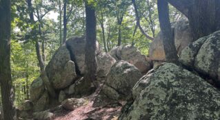
Because Rich Hole is a designated wilderness area, blue and white blazes that once marked the trail have been allowed to fade and are now infrequently visible. Be sure to pay close attention to the path you are following to avoid becoming lost.
Driving Directions
This hike is a point-to-point hike, requiring two cars. Head north on Main St. toward I-64 W. Continue onto US-11 N and turn left for I-64 W. After 12.3 miles, take exit 43 for Goshen, followed by a right onto VA-780. Take the first left onto St. Route 850/ VA-780. The first parking lot is on the right at about the 2.5-mile mark and the second lot is on the left about 3.5 miles from the first.
Insider's Tips
- Twenty streams cross the later section of the hike so hikers must use caution after a heavy rainfall.
- Be aware that stinging nettles will be at shoulder height around midsummer.