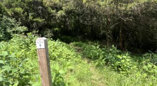
Whetstone Ridge Trail
Whetstone Ridge Trail is within George Washington National Forest and accessed from Milepost 29 on the Blue Ridge Parkway. It's popular for mountain biking and is part of the Virginia Mountain Bike Trail, but hikers looking for a challenge love it, too.
Photo: Hiking Upward
Description
Some have called Whetstone Ridge Trail a roller coaster thanks to the persistent elevation gains and losses along the way. At nearly 12 miles, it's an all-day, one-way trek that requires perseverance and fortitude.
Mountain biking enthusiasts love Whetstone Ridge Trail for the aforementioned thrilling hills, but hikers thrive on the trail as well. Rewarding view after rewarding view make the ascents worth the push. And after all, downhill is always a reward.
Mountain Bike Whetstone Ridge from Hunter on Vimeo.
Driving Directions
From the Lexington Visitor Center, drive west on Washington Street to a right onto Main Street (US-11 Business). Continue driving north on US-11 for approximately 15.8 miles and take a right onto Tye River Turnpike (Route 56). Drive 5.4 winding, steep miles to a left onto the Blue Ridge Parkway. Travel the Parkway for nearly two miles. The parking lot across from the Whetstone Ridge District Office is your arrival point.
Tips
- There are restrooms to the side of the Whetstone Ridge District Office.
- The first quarter-mile is on National Park Service property and biking is prohibited within NPS boundaries. If you intend to bike Whetstone Ridge, push your bike past the boundary and then hop on.
- If you're traveling with a companion, you're best served to leave a vehicle at the end point on Route 603 (Irish Creek Road) below the Blue Ridge Parkway.
Insider's Tips
- Gertie's Country Store is a great place to pick up food for the trail.
- If you're looking for a nearby accommodation, Steeles Tavern Manor and Shenandoah Valley Cabins offer options and amenities such as firepits, hot tubs, pool, and walking trails.


